Welcome to
BIG BEND NATIONAL PARK

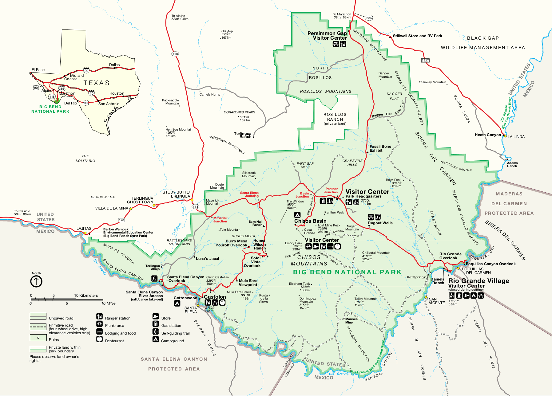
Big Bend National Park, situated in the rugged terrain of southwestern Texas along the Mexico-U.S. border, is a vast and awe-inspiring expanse of natural beauty. Encompassing over 800,000 acres, the park is named after a prominent bend in the Rio Grande River, which serves as its southern boundary. This remote and diverse landscape showcases a remarkable blend of desert, mountain, and river environments, creating a haven for nature enthusiasts and adventure seekers.
The Chisos Mountains, rising majestically from the Chihuahuan Desert floor, are a focal point of the park. Emory Peak, the highest point in the range, offers panoramic views of the surrounding landscapes. Hiking trails, such as the Lost Mine Trail and the South Rim Trail, lead visitors through canyons and up to high vistas, providing a glimpse into the park's geological and ecological diversity.
Information

The Rio Grande River, a natural border between the United States and Mexico, meanders through the park, creating dramatic canyons and offering opportunities for river activities. With its towering limestone walls, Santa Elena Canyon is a popular spot for canoeing and hiking.
Big Bend is a haven for biodiversity, hosting a wide range of plant and animal species adapted to the harsh desert environment. Visitors may encounter desert flora like cacti and yuccas, as well as wildlife such as mule deer, javelinas, and a variety of bird species.
As a designated International Dark Sky Park, Big Bend offers unparalleled stargazing opportunities, with clear night skies revealing a mesmerizing display of stars and celestial wonders. Whether exploring the vast desert expanses, navigating the canyons, or stargazing under the vast West Texas sky, Big Bend National Park invites visitors to immerse themselves in the grandeur of nature.
Best hiking trails in the Big Bend National Park
Big Bend National Park offers a diverse range of hiking trails, showcasing the park's unique geological features, stunning vistas, and diverse ecosystems. Here are some of the best hiking trails in Big Bend:
Emory Peak Trail: This challenging trail leads to the summit of Emory Peak, the highest point in the Chisos Mountains. Hikers are rewarded with breathtaking panoramic views of the surrounding landscapes.
South Rim Trail: Known for its spectacular views, the South Rim Trail takes hikers along the edge of the Chisos Mountains, providing expansive vistas of canyons and desert landscapes. It's a longer hike, but the scenery is well worth the effort.
Lost Mine Trail: A moderate hike that offers stunning views of the Chisos Mountains and the surrounding desert. The trail is known for its diverse plant life and is particularly beautiful during sunrise.
Santa Elena Canyon Trail: This easy trail leads into the majestic Santa Elena Canyon, where towering limestone cliffs rise dramatically on either side of the Rio Grande River. The trail provides a unique perspective of the park's geological formations.
Window Trail: An easy hike that takes you to a natural "window" in the Chisos Mountains, offering a framed view of the surrounding desert landscape. It's especially popular during sunrise and sunset.
Boquillas Canyon Trail: This trail leads into Boquillas Canyon, where hikers can enjoy a relatively easy walk along the Rio Grande River, surrounded by towering canyon walls.
Mule Ears Spring Trail: Offering a closer look at the iconic Mule Ears Peaks, this trail takes hikers through desert landscapes and provides opportunities for birdwatching.
Before embarking on any hike, it's essential to check trail conditions, carry sufficient water, and be aware of the park's regulations. Each trail in Big Bend National Park offers a unique and memorable experience, allowing visitors to immerse themselves in the diverse beauty of this West Texas gem.
Official name - BIG BEND National Park
Mailing Address: PO Box 129
Big Bend National Park, TX 79834-0129
Area: 801,163 acres
Coordinates: 29°15′0″N 103°15′0″W
Established - June 12, 1944
Attendance - 463,832 people per year

